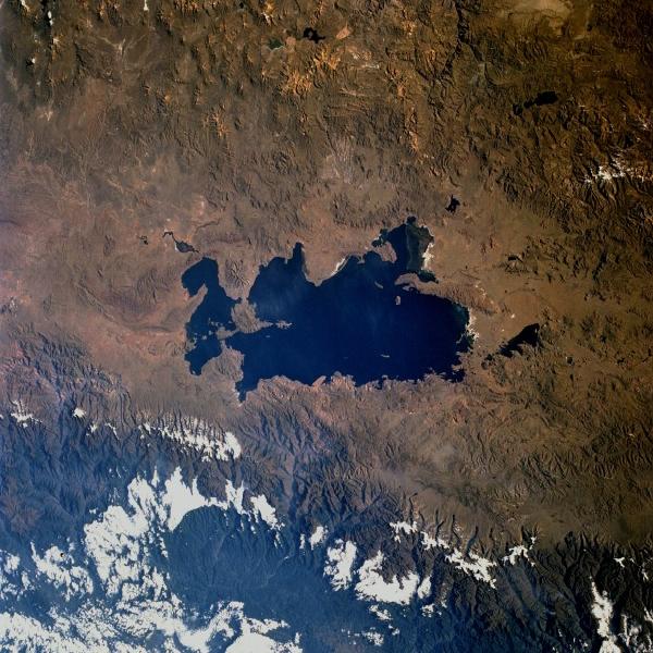
Lake Titicaca, Bolivia and Peru June 1993. Lake Titicaca, the largest freshwater lake in South America, can be seen in this low-oblique, southeast-looking photograph. Lake Titicaca is located in a depression in the Altiplano (high plains) between the eastern (greenish, forest-covered mountains east of the lake, partially obscured by clouds) and the western (brownish area west of the lake with numerous volcanic peaks) range of the Andes Mountains. Lake Titicaca covers an area of 3200 square miles (8300 square kilometers), is nearly 120 miles (190 kilometers) long, and has an average width of 45 miles (72 kilometers). Fed by many mountain streams that border the Altiplano, the lake is drained only by the Desaguadero River, which flows south into Lake Poopó (not visible in the photograph). Water levels can vary as much as 16 feet (5 meters) from season to season and year to year. Much of the lake water is lost through evaporation caused by intense sunshine and strong winds. Since the late 1980s, drought has plagued this region of the Altiplano, causing water levels in the lake to drop below normal. The whitish areas scattered around the lakeshore are newly exposed lake bottom areas. A small tail-like portion at the northern end of the lake (visible in the photograph) has been cut off from the main body of the lake because the water level has receded. Drastic drops in water level in the lake could eventually affect the moderating climate of this high-altitude lake 12 500 feet (3800 meters) above sea level, which could lead to reduced agricultural crop yields. The agricultural crops of wheat and maize help sustain many Indians that live along Lake Titicaca’s shores. (Refer to STS-51G-037-0028 for an earlier photograph and description of Lake Titicaca.)
|
|